Posted
Weather outlook for summer 2026: will a super El Niño heat up your season?
Updated:
Posted:
Before booking that paddling trip or back country campsite, or the extended beach weekend, you might be asking yourself, what will the weather be like in Western Canada for summer 2026?
Of course, day to day weather is fickle especially in Alberta and BC. Things can change quickly, whether you're in the Rockies or the lower mainland, but having a sense of the bigger trends at play can help with your preparations.
And yes, the rumours are true: an El Niño is developing in the tropical Pacific that could increasingly influence weather patterns in the months ahead.
But it's not the only factor at play.
Winter variability affects spring warm up
Winter has a big part to play in what summer looks like. This past winter in western Canada was marked by stormy periods with substantial precipitation, helping build an impressive snowpack in many areas of the Rockies and Columbia Mountains.

Photo:
Madeline Williams
Lingering winter temperatures and snow across the Rockies impacted spring conditions.
Areas east of the Rockies experienced several Arctic outbreaks, bringing about a more sluggish start to spring in Alberta.
Farther west, winter was warmer than normal across southern British Columbia. Vancouver Island and the South Coast were hit by multiple atmospheric river events.
While these systems brought welcome moisture, they also frequently delivered warm rain and above-normal temperatures that melted the snowpack.
By spring, many areas across southern and central British Columbia were left with well-below normal snow levels.

Photo:
Jeremy Derksen
Spring conditions in Jasper, April 2026, showing a dry valley contrasted with snowy mountain peaks.
Continued warm and dry weather brought about an early spring across southern and central British Columbia, along with growing drought conditions and elevated fire danger by early to mid-May that also began to spread into southern Alberta.
This is part of what is setting the stage for the summer ahead.
Summer 2026 weather outlook
Something big is brewing in the Pacific
With an El Niño developing in the tropical Pacific, there is increasing potential to influence weather patterns in the months ahead.
El Niño is the warm phase of a recurring ocean-atmosphere pattern in the tropical Pacific that develops every two to seven years.

Photo:
Copernicus Climate Change Service
Forecast global sea surface temperature anomaly, or difference from normal, for June - August 2026. El Niño conditions can be seen in the central and eastern tropical Pacific, where temperatures are forecast to be 2°C or more above normal. This is an “ens
During El Niño, sea surface temperatures in the central and eastern tropical Pacific become warmer than normal.
This can fuel vigorous thunderstorm activity, which releases large amounts of heat into the atmosphere that can reshape global wind patterns and influence the weather thousands of kilometres away.
Will 2026 be a Super El Niño?
This year’s event has the potential to become strong, perhaps even rivaling past “super” events like 1982-83, 1997-98, and 2015-16.
Its influence on summer weather in North America, however, is less reliable than during winter.
find YOUR zen
Sign up for ZenSeekers enews for local culture & outdoor adventure across Western Canada.
No two El Niño events behave exactly the same, and even past strong events have produced very different summer temperature and precipitation patterns across western Canada.
That means El Niño is only one piece of a much larger puzzle, limiting confidence in the finer details of the seasonal forecast.
Forecast confidence should improve heading into fall and winter 2026/27, when El Niño typically exerts a stronger and more predictable influence on the atmosphere.
Other weather factors at play
Other factors may also shape the summer ahead, including sea surface temperatures in the North Pacific and ongoing drought patterns across western North America.

Photo:
Copernicus Climate Change Service
Forecast temperature anomaly, or difference from normal, for June - August 2026 across North America. Warmer than average conditions are forecast for western Canada.
One area of unusually warm water east of Japan has persisted since 2020 and may be helping shape the jet stream in ways that favour hotter and drier summer conditions across western Canada.
Combined with the developing El Niño, this pattern could help give summer 2026 a familiar flavour.
What the models show
Climate models from several international forecasting agencies increasingly agree that a strong to very strong El Niño is likely to develop by late summer or early fall.
That growing consistency increases confidence that the event will become a major driver of global weather patterns later this year.

Photo:
National Oceanic and Atmospheric Administration
This graphic shows how the Great Ocean Conveyor Belt circulates warm and cool currents, impact changing weather patterns and climate worldwide.
A developing El Niño combined with unusually warm ocean temperatures globally means large amounts of heat are available to the atmosphere.
This can increase the severity of extreme weather events such as heat waves and drought, while also allowing the atmosphere to hold more moisture that could potentially intensify heavy rainfall events.
For western Canada, most seasonal models continue to point toward another warmer-than-normal summer.
Precipitation forecasts remain far less certain—which is typical of seasonal outlooks—with some regions potentially ending up wetter than normal and others drier.
Areas already dealing with dry conditions, particularly across central and southern British Columbia and parts of southern Alberta, could see worsening drought and elevated wildfire danger if hot and dry weather dominates through summer.
Seasonal rains during late May and June will be important in limiting those impacts.
What does that mean for you, as you look to get out and adventure this season?
1. You can get an early start on your hiking season in southern and coastal areas of Western Canada.
As it stands now, alpine hiking and scrambling season will likely begin earlier across coastal and interior British Columbia than in areas farther north and east into the Rockies, where a significant snowpack remains.
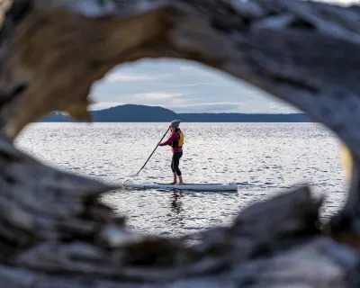
2. Be aware of high water conditions in alpine areas and rivers, especially during late spring runoff.
In the mountains, expect swollen streams and fast snowmelt through late spring. Before heading out for a paddle, check reports via Alberta Environment or the BC River Forecast Centre.
3. Be prepared for ticks.
More warmth is favourable to these tiny pests, so bring the tweezers and do regular tick checks whenever you're spending time in forests, grasslands or trails. Here are some good tick safety tips to follow.
4. Cooling off will be key during prime summer months.
Plan to spend time in shady forests or cool waters to keep your chill through the hottest months, and avoid strenuous activity during the hottest times of day if you can. Check out some the stories below, for some inspiration on where to go to get on the water.
No matter how the season unfolds, there should be plenty of opportunities to get outside in the weeks ahead under skies that, at least early this season, remain largely smoke-free. Stay safe and enjoy the summer!